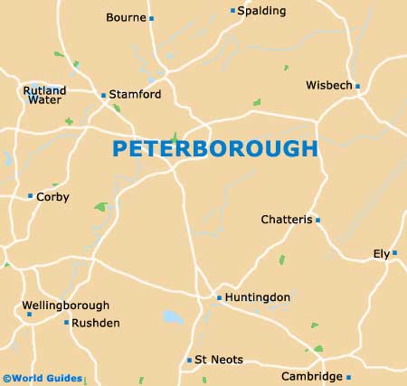
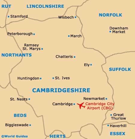
Peterborough Maps and Orientation
(Peterborough, Cambridgeshire, England, UK)
Located on the eastern side of
England and within the East Anglia region, the city of Peterborough lies on the north-easterly side of the county of Cambridgeshire. Peterborough now serves as the region's industrial capital and is the biggest city by far in Cambridgeshire, in terms of both area and population, and considerably larger than the more famous university city of
Cambridge.
Often referred to as the 'Gateway to the Fens', Peterborough stands on the edge of a huge expanse of historic marshland and agricultural lands, which contrasts greatly with the city's dense infrastructure. In recent years, the city has expanded greatly in size and has become home to a significant Italian community, as well as further immigrants from eastern Europe.
Maps and Orientation of the City
The major rail network converging in Peterborough really does set this city on the map, offering excellent transport connections to the whole of England,
Scotland and
Wales. Both the city's bus and railway station are just a short walk from the city centre and lie on its westerly outskirts, off the Bourges Boulevard (A15).
Free maps of Peterborough and Cambridgeshire are best obtained from the city's Tourist Information Centre (TIC), which is located within the Minster Precincts area, near to the Deanery, the cathedral and Wheel Yard, and off Dean's Court.
- Birmingham - 136 km / 85 miles (two hours, west)
- Boston - 62 km / 39 miles (55 minutes, north)
- Bury St. Edmunds - 104 km / 65 miles (one hour and 20 minutes, south-east)
- Cambridge - 62 km / 39 miles (55 minutes, south-east)
- Coventry - 107 km / 67 miles (one hour and 30 minutes, west)
- Derby - 120 km / 75 miles (one hour and 45 minutes, north-west)
- Huntingdon - 37 km / 23 miles (35 minutes, south)
- Ipswich - 153 km / 95 miles (two hours, north-west)
- Kettering - 50 km / 31 miles (45 minutes, south-west)
- King's Lynn - 58 km / 36 miles (50 minutes, north-east)
- Leicester - 66 km / 41 miles (one hour, west)
- Letchworth - 80 km / 50 miles (one hour and ten minutes, south)
- Lincoln - 109 km / 68 miles (one hour and 30 minutes, north)
- London - 138 km / 86 miles (two hours, south)
- Northampton - 69 km / 43 miles (one hour and five minutes, south-west)
- Norwich - 128 km / 80 miles (one hour and 55 minutes, east)
- Nottingham - 91 km / 57 miles (one hour and 25 minutes, north-west)
- Nuneaton - 114 km / 71 miles (one hour and 45 minutes, west)
- Sandy - 58 km / 36 miles (50 minutes, south)
- Skegness - 93 km / 58 miles (one hour and 25 minutes, north-east)
- Spalding - 34 km / 21 miles (35 minutes, north)
- St. Neots - 45 km / 28 miles (40 minutes, south)
- Stamford - 22 km / 14 miles (25 minutes, west)
- Stevenage - 86 km / 54 miles (one hour and 15 minutes, south)
- Tamworth - 142 km / 89 miles (two hours, west)
Map of the United Kingdom

Map of Cambridgeshire
Map of Peterborough